
Route 66 - Roadmap - Illinois Part 1 (turn by turn)
These towns are traversed on Route 66 in Illinois
Chicago – Cicero – Berwyn – Lyons – McCook – Countryside – Indian Head Park – Welco Corners – Romeoville – Joliet – Elwood – Wilmington – Braidwood – Godley – Braceville – Gardner – Dwight – Odell – Cayuga – Pontiac – Chenoa – Lexington – Towanda – Normal – Bloomington – Shirley – Funks Grove – McLean – Atlanta – Lawndales – Lincoln – Broadwell – Elkhart – Williamsville – Sherman – Springfield – Glenarm – Pawnee Junction – Divernon – Farmersville – Waggoner – Litchfiled – Mt. Olive – Staunton – Hamel – Edwardsville – Mitchell – Granite City – Venice

Chicago:
The start of Route 66 has moved several times. Originally, Route 66 began on Jackson Boulevard/ Michigan Avenue. In 1933, the start, and the end too, was moved east onto the reclaimed land for the world fair to Jackson and Lake Shore Drive. In the year 1955, Jackson Blvd became one way west of Michigan Avenue and Adams Street became the westbound US-66. However the start of US-66 remained on Jackson at Lake Shore Drive. So, even while currently Adams Street at Michigan Avenue is marked as the starting point, Route 66 never departed from there.
The ending point is easier to start from post 1933 at Jackson Boulevard and Lake Shore Drive, prior to 1933 it was at the intersection of Jackson Boulevard and Michigan Avenue.
Start from the intersection of Lake Shore Drive and Jackson Drive. Take Jackson Drive to the west. Turn right onto Michigan Ave. Turn next left onto Adams Street. Cross over the South Branch of the Chicago River. Cross over I-90 (Kennedy Expy.).
After crossing Ashland Avenue, turn southwest onto Ogden Avenue. Continue on Ogden Avenue at the intersection with Western Avenue. Cross under the railroad tracks. Ogden Ave. passes through Douglas Park. You are now in Cicero, IL.

Cicero – Berwyn
Continue on Ogden Avenue under the Railroad interchange.
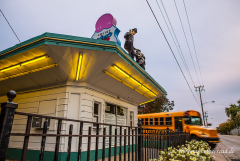
The Cindy Lyn Motel is on the left. Henry’s Drive In, is located at 6031 W Ogden Ave.
On other Route 66 attraction ist the Robin Hood Muffler Shop at 6131 W Ogden Ave.
Cicero was in Al Capone’s days riddled with tunnels, used by gangsters and bootleggers. Your are now in Berwyn. Continue on Ogden Avenue.

McCook – Welco Corners
Section pre 1928
Continue on Ogden Ave. at the intersection with Harlem Ave. Cross Pershing Rd.
Cross the Des Plaines River. Continue on Ogden Ave at the intersection with Joliet Avenue. Continue as Ogden Ave turns slight left. Turn left onto Lawndale Ave.
Cross 47th St. You are now in McCook.
Turn right on Joliet Rd. to rejoin the later alignment after 1928.
Section after 1928
As you enter Lyons, turn south at the White Castle onto Harlem Avenue (IL-43).
After about 0.4 mile, turn southwest just past the Chevrolet dealer onto Joliet Road.
Follow Joliet Road as it winds trough Lyons. Cross the Des Plaines River.
In McCook. Continue straight at the intersection with Lawndale Ave. Continue on Joliet Road. Cross under IL-17. Cross over the railroad tracks. General Motors Electro-Motive on the right. You are now in Countryside. Continue on Joliet Rd.
Continue straight at the intersection with La Grange (US-45, US-20, US-12).
You will find The Wishing Well Motel on Joliet Road / Brainard Avenue. Continue on Joliet Rd.Pass under I-294 (Tri State Tollway). Enter I-55 at exit 277. Joliet road disappears under I-55. Exit immediately to North County Line Rd. at exit 276B.
Turn left onto Case Dr. Turn next left onto Joliet Road. Continue on Joliet Road. Dell Rhea’s Chicken Basket is on the left before the intersection with IL-83, at 645 Joliet Road. Get back onto I-55 at exit 274. Continue on I-55. Continue on I-55 at the Intersection with I-355.
Romeoville – Joliet Section pre 1940
Until 1940 this was the only Route 66 routing. After that, it became the ALT-66 routing.
Exit I-55 onto Joliet Road at exit 268. At exit 268 (locally known as Welco Corners): Old gas station & Cafe and Montana Charlie’s Flea Market.
White Fence farm, a restaurant on Joliet Road 2 miles after the I-55 exit, since 1954.
Continue southwest on Joliet Road. You are now in Romeoville. Enter Joliet on IL-53 (Broadway Street.) Turn left onto Ruby St. Ruby Street Bridge over the Des Plaines River. Cross the Des Plaines River. Turn next right onto Chicago St. Follow IL-53 as it turns slightly right. Take a Right onto Jackson St. Immediately, take a left onto Ottawa Street. Union Station at 50 E. Jefferson Street. (US-30). Route 66 Welcome Center in the Joliet Area Historical Museum at 204 N. Ottawa St. Rialto Square Theatre at 102 N. Chicago. The Olde Keg at 20 W. Jackson St. (US-30). Follow US-6 as it turns left towards Chicago St. Follow Chicago St. south across I80.

Elwood
Just north of Elwood: after crossing Manhattan Rd.
1.5 miles later: turn left and right to change from the 4 lane alignment to the older. Follow Chicago Street. After 1.3 miles, turn right onto Mississippi Road. You ar now in Elwood. After entering Elwood on Mississippi Rd., make a left onto Douglas St.
Rejoin IL-53 south of Elwood. Joliet Arsenal: IL-53 crosses through the Joliet arsenal, a former ammunition plant and storage facility, now being returned to nature.
     |

Wilmington – Godley – Braceville
Continue on IL-53 through Wilmington. In Wilmington follow IL-53 as it turns right onto Baltimore Street. Gemini Giant and the Launching Pad drive-in, located on 810 E. Baltimore Street at East Street on the right.
You are now entering Braidwood. Continue on IL-53. Polk-a-Dot drive-in, a roady classic at 222 N. Front St. in Braidwood on the right side. In Gouldy continue driving on IL-53. You are entering Gradner

Gardner – Dwight – Odell
Continue on IL-53. Follow IL-53 as it turns left, away from the railroad.
0.5 miles later, turn right onto Main Street. At the intersection with IL-129 and IL-53 (both are Route 66 alignments), turn left onto IL-53. Use the Frontage Road southeast of I-55, known as US-66
Gardner has a two cell historic jailhouse, restored by the community, since 1910. Exit Gardner on the frontage road southeast of I-55. Route 66 is stuck between I-55 and the railroad. You ar now in Dwight. After the Interstate veers off to the right, half a mile later, make a left turn onto Brewster Road to stay with the railroad.
At the T intersection, make a left onto IL-47 South. Cross the Conrail railroad (east-west). Continue straight onto Waupansie St. as IL-47 turns south across the railroad.
Follow Waupansie St. as it curves west and then south. Cross IL-17 (Mazon Ave.) to old 66 (south).
There ar many attractions in Dwight: Ambler-Becker Texaco gas station, located at 417 W. Waupansie St. and Route 66 Service center on 209 South Old Route 66.
The Feddersen’s Pizza Garage it’s located at 309 S. Old Route 66.
Dwight has a stone railroad depot built in 1891. Behind Dwight you have reached the next town, Odell.
Curve right onto Odell Road. Behind you on Odell Rd is an pre Route 66 alignment (1918). Turn left onto old highway 66 at the southern end of town and continue southwest. After the Interstate veers right, turn left on Odell Rd. into town when historic highway 66 veers away from the railroad track. At the intersection 2nd Street. continue straight on West Street.Turn next right onto Prairie Street. Turn 2nd left onto South West Street. In odeel you’ll find John Stonepiper Mobil Gas Staion and a restored Standard Oil Gas Station. In 313 West Hamilton Street there is the old Chruch.
Gardner – Dwight – Odell
Larger Map

Cayuga – Pontiac
Continue on West Street. As West Street joins old Highway 66, turn left. You are in Cayuga. At the intersection with 1600 Rd., turn left onto old route 66.
The next bigger town is Pontiac.
Follow southeast along the railroad tracks. Follow right onto 1830 Road.
Follow left onto Division Street. Make a right onto Lincoln Avenue. Follow the turn south onto Ladd St (IL-23). Turn east on Howard St. (IL-116) to Main St. to get to the Route 66 Museum that’s been built in the old firehouse (opened in June 2004).
Continue on Ladd St. as it rejoins the railroad. An old bridge was preserved by the Illinois Route 66 Association. The bridge features an old painted sign designating it as part of IL-4 as well. Make a right turn onto Reynolds St.
Ladd St. straight ahead dead-ends but was Route 66. Next left onto Old highway 66
Rodino Sq. Building used to be a Pontiac attraction till 1989.
Cayuga – Pontiac
Larger Map
Chenoa – Lexington – Towanda
Behind Pontiac go back to the Old Route 66 and continue along the railway line. The place Chenoa is a sleepy little town with some nice buildings to drive into the village well worth it. Sequence of Route 66 and continue along the I-55.
On Route 66 between I-55 and the railroad you reach Lexington. In Lexington, a very long piece of very old Route 66 can be seen, there is a kind of “Walk of Fame” in the “Historic Route 66”.
Result, more and Route 66 On the one hand the whole time runs parallel the very old piece of road that must not be driven, however. You can reach Towanda.
Chenoa – Lexington – Towanda
Larger Map
Chicago, Illinois – Towanda, Illinois
Bigger Map
The Route 66 in Illinois is a total of 301 miles or 485 km long
All data I give to you has been researched to the best of my knowledge and belief. Nevertheless, to me, of course, be a mistake. In addition to my information, please use always current maps or guidebooks.