
Route 66 - Roadmap - Illinois - Part 2 (turn by turn)
These towns are traversed on Route 66 in Illinois
Chicago – Cicero – Berwyn – Lyons – McCook – Countryside – Indian Head Park – Welco Corners – Romeoville – Joliet – Elwood – Wilmington – Braidwood – Godley – Braceville – Gardner – Dwight – Odell – Cayuga – Pontiac – Chenoa – Lexington – Towanda – Normal – Bloomington – Shirley – Funks Grove – McLean – Atlanta – Lawndales – Lincoln – Broadwell – Elkhart – Williamsville – Sherman – Springfield – Glenarm – Pawnee Junction – Divernon – Farmersville – Waggoner – Litchfiled – Mt. Olive – Staunton – Hamel – Edwardsville – Mitchell – Granite City – Venice
Towanda – Normal – Bloomington – Shirley – Funks Grove
Towanda is quickly passed through, there are no special Route 66 attractions except the old pieces of the road that you can commit. There are there a few information signs erected on the history of Route 66
Normal / Bloomington bigger towns, always follow the Route 66 bypass signs, no matter from which side you put into traveling to the cities, the bypass is signposted just fine.
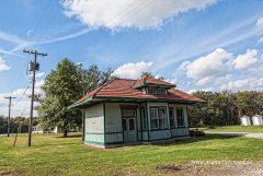
Behind Bloomington becomes the landscape rural again, you reach Shirly and Funks Grove. In Funks Grove you can buy maple syrup in season but you have to do on appointment. In the Funks Grove are the “Walker Store & Gas Station” an the “Shirly station”. Both buildings are very old and run down.

McLean – Atlanta – Lawndales
The Old Route 66 follow, always parallel to the railroad and interstate. The left-hander followed by Steward Street, then right onto Carlisle Street. Cross the Elm Street, then turn off in McLean on Main Street.
At the next corner on the Dixie Road, turn right (US-136 W). The U.S. 136 exit at the railroad crossing again and go back to the Old Route 66.
You reach Atlanta, IL.
The Arch Street runs through Atlanta, past the “Tall Paul” (Bunyon Giant), another Muffler Man bend on Route 66 At the end of the road turn right back one onto Old Route 66. In Atlanta, there are next to “Tall Paul” and “Bunyon’s Statue Tall Paul” the “Palms Grill Café” and “JH Hawes Grain Elevator Museum “to see.

Lincoln – Broadwell – Elkhart – Williamsville
Follow the Lincoln Parkway or Old Route 66, sometimes parallel to Interstate, sometimes located Route 66 from I-55, but still follows the railway line. Through the village leads the Kickapoo Street. The City Hall and the cinema are the attractions in the city. The old Texaco gas station is coming behind Lincoln on the right side, from the east.
Route 66 is called behind Lincoln Logan County Road 22 and runs along the I-55. Follow her through Elkhart and Williamsville. In Williamsville at 171 Elm Street you’ll find “Die Cast Car Sales.”

Sherman – Springfield
In Williamsville W Outer Road follow parallel to I-55 to Sherman. Drive on I-55 Business, recognizable by the green signs.
Follow the I-55 Business to Springfield, IL. In Springfield follow the Route 66 by attractions or drive around the city on I-55 Business or I-55.
Check out the “Crazy Dog Drive In” in the 2935 South 6th Street, then go to “Bill Shea’s Gas Station” in the 2075 Peoria Road. Sequence of I-55B. In Springfield, there is an old and a new “State Capitol.” That, “Old State Capitol” is in the 1 North Old State Capitol Plaza, the new in the 401 South 2nd Street. Result of the I-55B, Route 66 is characterized in all of Springfield with the brown signs. Another “Muffler Man” is before the “Lauterbach Tireshop” in the 1569 Wabash Avenue.

Glenarm – Pawnee Junction – Divernon
In Springfield drive for a few miles on I-55 until the Exit 88. Than turn right on Palm Road. Drive parallel to I-55. You reach the city of Glenarm. Always stay on the Fraze Road (Old Route 66). At the exit 82 drive onto the I-55 or take the 104 to Divernon. Until Farmersville follow the Frontage Road parallel to Interstate 55.
     |

Farmersville – Waggoner – Litchfiled
Follow Frontage Road to Farmersville, a short trip into town is worth it. At the I-55 you’ll find the “Art’s Motel”. Follow of the Frontage Road / Route 66 to Waggoner. In Waggoner, you find the “Magnuson Grand Hotel”. Stay behind Waggoner on Frontage Road on the left hand side of the Interstate on CO Road 1600 N, under cross the I-55 and follow the Frontage Road on the right hand side of the interstate. Litchfield is a larger town on the Route 66 with many attractions. The Route 66 is divided at the beginning of town, follow the left lanes to get to the “Skyview Drive-In”, an open-air cinema. Drive across Union Avenue, follow the signs for Historic Route 66 The “Litchfield Museum & Route 66 Welcome Center” is located on the 334 Historic Old Route 66. Across the street is the “Ariston Café”, a few hundred yards on the right hand side is the “Belvedere Motel and Café.”

Mt. Olive – Staunton
Behind Litchfield follow Old Route 66, the road leads along the railway to the left. On the Mount Olive Road, it goes through town. The “Soulsby Service Station” is a restored gas station in 1926, you can find it on the Historic Route 66 (710 West First Street). Behind Mount Olive follow Highway 138, then turn left onto Old Route 66. Follow the Old RT 66 to Interstate 55 at the intersection, turn right and go straight to Staunton. The “Country Classic Cars LLC” is located in the East Frontage Road. A must for every fan. Right leads to Route 66 following signs to Staunton. In Staunton, visit “Rich Henry’s Rabbit Farm” in the 1107 Historic Old Route 66

Hamel – Edwardsville – Mitchell
From Staunton, there are two ways to follow the route 66, either via Highway 4 after Hamel or back towards the interstate on the Frontage Road. Between Staunton and Hamel is the “Church of the Neon Cross” on the Frontage Road. A few miles away is a beautiful “Antique Mall” with another Muffler Man, the Harley Davidson Man, and a few other characters, a UFO and a pink elephant. Follow behind Hamel the Old Route 66 to after Edwardsville, IL. In the village is the Wildey Theatre in 252 North Main Street. Follow Bluff Road, then the “Chain of the Rocks Road” to Mitchell.

Granite City – Venice – St. Louis
From Mitchel follow the West Chain of the Rocks Road, turn right onto Hwy 3 (Lewis and Clark Road). Cross the McKinley Bridge. On the other side of the bridge the street does not continue, you’re now in Missouri. Drive back on the bridge and follow the brown signs for Route 66 through St. Louis.
Towanda, Illinois- Venice, Illionis
Bigger Map
The Route 66 in Illinois is a total of 301 miles or 485 km long
All data I give to you has been researched to the best of my knowledge and belief. Nevertheless, to me, of course, be a mistake. In addition to my information, please use always current maps or guidebooks..