Route 66 - Roadmap (turn by turn)

Overall, the Route 66 is 2448 miles or 3939 kilometers long she leads by 8 states.
Illinois – 301 Miles
Missouri – 317 Miles
Kansas – 13 Miles
Oklahoma – 423 Miles
Texas – 186 Miles
New Mexico – 487 Miles
Arizona – 401 Miles
California – 314 Miles

Route 66 no longer exists in its entirety. Some sections have been replaced by interstates.
Therefore, to stay always on Route 66 is not easy, in some places you have to look for old route segments.
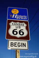
The Route 66 Association has installed, at most places brown and white signs with the words: “Historic Route 66, for the convenience of the traveler “. However, these are not always placed as signs at intersections, but only as a confirmation that you are on the right road somewhere in the middle of towns or behind intersections. We have always followed these signs and we didn’t get lost.

Unfortunately, there is no indication as to East or West, so that one part can not be sure if one is heading in teh right direction after having been on the interstate. Therefore, I recommend a navigation device, or at least a road map to be sure that you are traveling in the right direction.
In a few places the signs are completely missing making it difficult to find the correct route. But once you get back to the interstate signs mark Historic Route 66. In addition to the brown signs there are blue signs on Route 66 byway. These are then the byway roads which do not run through towns.
I have sorted by state all places listed by the historic Route 66. In addition, you will find each state’s route on Google Maps.
Route 66 – on Google Maps
LargerMap
For optimal planning to drive the Route 66 I recommend the following books:
- Tom Snyder – Travelers Guide an Roadside Companion
- Drew Knowles – Adventure Handbook
- Jerry Mc Clanahan – EZ 66- EZ66 Guide for Travelers
